About Skytech Dynamics Manufacturing Company
Skytech Dynamics Overview and Unmanned Aerial Systems UAS Leadership
Skytech Dynamics Inc enters the drone arena with a clear purpose and steady ambition. Founded in early 2025 and headquartered in New York, the company focuses on unmanned aerial systems UAS and advanced drone solutions that reshape how industries gather and read data. And right from day one, the mission feels practical. Deliver sharp geospatial data, reduce field costs, and speed up decision cycles.
According to industry research, the global drone services market is projected to exceed $63 billion by 2030. Skytech Dynamics positions itself squarely inside that surge. The firm builds its reputation on high-precision mapping, efficient deployment, and dependable execution. But more importantly, it brings clarity to sectors that rely on measurements down to the centimeter, or roughly 0.4 inches.
LiDAR Surveys and Aerial 3D Mapping for Construction and Forestry
LiDAR surveys sit at the core of Skytech Dynamics’ commercial offerings. Using aerial 3D mapping technology, the company delivers dense point clouds that support construction, land development, forestry drone mapping, and urban planning drone surveys. And accuracy matters here. Modern LiDAR payloads capture millions of data points per second, generating topographic models with vertical accuracy within 2 to 5 centimeters, or about 0.8 to 2 inches.
For developers and civil engineers, that translates into fewer site visits and tighter project timelines. Data reveals that drone-based topographic surveys can reduce field time by up to 50 percent compared with traditional ground crews. Skytech Dynamics leverages that efficiency to keep projects on track and budgets stable.
- Centimeter-level elevation models
- Rapid terrain modeling over hundreds of acres
- Digital surface and digital terrain models
Thermal Drone Inspections for Infrastructure and Solar Assets
Thermal drone inspections provide another powerful tool in the Skytech toolbox. By integrating infrared sensors, the company identifies heat anomalies across electrical utilities, industrial equipment, and solar farms. And the payoff appears quickly. Early detection of overheating components can reduce maintenance costs by 20 to 30 percent, according to energy sector studies.
Solar panel thermal inspection proves especially valuable. A single defective module in a 1 megawatt array can reduce output by several kilowatts. Skytech Dynamics’ thermal imaging detects those hotspots before energy losses multiply. The same logic applies to building energy audits and industrial equipment monitoring drones. Spot the issue early, fix it fast, move on with confidence.
Custom Aerial Data Solutions and Multispectral Imaging Drones
Not every project fits a standard template. And Skytech Dynamics understands that. Through custom aerial data solutions, the team combines RGB aerial imaging, multispectral imaging drones, and thermal sensors in a single mission profile. That layered approach gives clients more than pretty pictures. It delivers actionable insight.
For agriculture and environmental monitoring, multispectral data tracks plant health through normalized difference vegetation index metrics. In forestry drone mapping, that helps identify stress zones across hundreds of acres in one flight. And when integrated with geospatial data analytics, those insights guide smarter land management decisions.
- RGB high-resolution mapping
- Multispectral crop and vegetation analysis
- Integrated thermal and LiDAR payload options
FAA Compliant Drone Services and Safety-Driven Operations
Safety and compliance anchor Skytech Dynamics’ daily operations. Every mission runs under FAA compliant drone services guidelines, supported by certified pilots and experienced technicians. And that discipline shows. Proper airspace authorization, risk assessment, and pre-flight planning reduce operational delays and protect client investments.
Rapid deployment also defines the company’s service model. Traditional inspection crews may require days of setup. In contrast, a drone team can mobilize within hours, covering miles of transmission lines or large construction parcels in a single flight window. For clients watching downtime costs climb into thousands of dollars per day, speed equals savings.
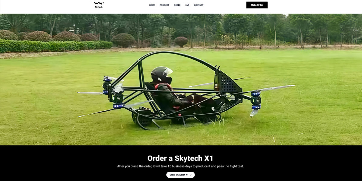
Skytech X1 Drone Platform and High-Precision Geospatial Data Analytics
At the hardware level, the Skytech X1 drone platform supports the company’s data-driven strategy. Built for stability and sensor flexibility, Skytech X1 carries LiDAR scanners, thermal cameras, and RGB payloads in modular configurations. And that adaptability keeps mission planning efficient across diverse industries.
Geospatial data analytics converts raw imagery into structured insight. Orthomosaics, digital elevation models, and volumetric calculations give clients measurable figures rather than guesswork. For example, stockpile volume calculations derived from drone surveys can achieve accuracy within 1 to 3 percent, offering tight inventory control for mining and construction operations.
Disaster Response Drones and Search and Rescue UAS Initiatives
Beyond commercial work, Skytech Dynamics supports public safety missions. Through disaster response drones and search and rescue UAS deployments, the company volunteers aerial capabilities for emergency scenarios. And time matters in those moments. A drone equipped with thermal sensors can scan large wooded areas in minutes rather than hours.
Community engagement strengthens the firm’s identity. Technology serves a purpose when it improves real outcomes. Whether assisting first responders during floods or supporting wildfire perimeter mapping, Skytech Dynamics applies the same precision and discipline seen in commercial contracts.
Market Position and Industry Outlook for Advanced Drone Solutions
The drone services sector expands at an estimated compound annual growth rate above 20 percent through the end of the decade. Skytech Dynamics Inc positions itself as a cost-effective yet high-precision provider inside that upward curve. And clients benefit from lower operational overhead compared with manned aircraft inspections, which often cost several thousand dollars per hour.
Headquartered in New York and operating nationally, Skytech Dynamics focuses on delivering clear, usable data rather than vague promises. Construction managers gain site clarity. Utility operators secure asset health. Environmental planners access measurable terrain intelligence. And in a market where speed and accuracy define competitive edge, Skytech Dynamics Inc keeps its flight path steady and purposeful.